I added a map and gave it six control points. The rectification fails.
https://warper.wmflabs.org/maps/2302#Rectify_tab
Description
Description
Event Timeline
Comment Actions
Hi, many thanks for this bug report.
gdal_translate -a_srs '+init=epsg:4326' -of VRT /home/warperdata/src/Himalayan_river_catchments.jpg.tif /home/warperdata/dst/2302_temp.vrt -gcp 249.0261904762, 1214.95119047615, 60.0, 24.0 -gcp 398.63452380954, 249.8952380952, 60.0, 45.0 -gcp 1801.0071428572, 253.1833333334, 100.0, 45.0 -gcp 1960.4797619045, 1218.2392857142, 100.0, 24.0 -gcp 931.30595238085, 1272.49285714273, 76.0, 24.0 -gcp 962.54285714276, 294.2845238094, 76.0, 45.0
gdalwarp -rn -dstalpha -s_srs 'EPSG:4326' /home/warperdata/dst/2302_temp.vrt /home/warperdata/dst/2302.tif -co TILED=YES -co COMPRESS=LZW
This fails, "ERROR 1: Failed to compute GCP transform: Transform is not solvable"
gdalwarp -rn -order 1 -dstalpha -s_srs 'EPSG:4326' /home/warperdata/dst/2302_temp.vrt /home/warperdata/dst/2302.tif -co TILED=YES -co COMPRESS=LZW
Works

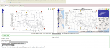
The work around was to select 1st Polynomial in the Rectify Method (see attached screenshot), or to add more points to the image.
Ideally the system should check to see if there is that error and try the first polynomial. I'll make an issue on github.