Page MenuHomePhabricator

Kartotherian doesn't correctly render text consisting only of numbers
Open, LowPublic

Assigned To
None
Authored By
Jc86035
Jun 26 2018, 5:11 PM
Referenced Files
F31938227: korvalteed.png
Jul 17 2020, 10:02 AM
F27972716: Screenshot 2019-01-21 at 3.23.01 PM.png
Jan 21 2019, 7:25 AM
F27972702: Screenshot 2019-01-21 at 3.18.50 PM.png
Jan 21 2019, 7:20 AM
F22690446: Screen Shot 2018-06-27 at 1.09.42 AM.png
Jun 26 2018, 5:11 PM
F22690447: Screen Shot 2018-06-27 at 1.07.44 AM.png
Jun 26 2018, 5:11 PM

Description

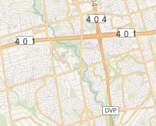
It seems that someone has decided to mess with the font for route labels, making the numbers and character spacing larger without also modifying the surrounding boxes (or even non-numeric text) to match. The route labels looked normal at some previous point in time, but I don't remember when the change occurred (it was probably in the last year and a half or so).

Screen Shot 2018-06-27 at 1.07.44 AM.png (368×454 px, 188 KB)

Shields which contain both letters and numbers seem to be fine.

Screen Shot 2018-06-27 at 1.09.42 AM.png (688×524 px, 250 KB)


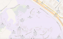
Rendering issues also occur with any other text lines (SVG <tspan>) which only contain digits; compare "Residence 10" (10 is oversized) to "Residences 3 & 4 (Down)" and "Science Park (Phase 1)".
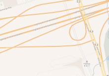
Screenshot 2019-01-21 at 3.18.50 PM.png (1×2 px, 1 MB)

Event Timeline

Jc86035 reopened this task as Open.
Jc86035 claimed this task.
Jc86035 removed Jc86035 as the assignee of this task.
Jc86035 edited projects, added Maps (Kartographer); removed Maps.

@Jc86035 could you provide links for the issue? So we can have more info to work on.

MSantos edited projects, added Maps (Tilerator); removed Maps (Kartographer).
MSantos edited projects, added Maps (Map-Styles); removed Maps (Tilerator).

@MSantos The first image is of the maps.wikimedia.org map around Toronto. I don't know how the stylesheets work so that's all the information I have.

No problem, if you would like to know more about how our map styles work, please have a look into https://github.com/kartotherian/osm-bright.tm2

@MSantos: This is the same issue as https://github.com/kartotherian/osm-bright.tm2source/issues/63. I think it's definitely something somewhere that's converting strings to integers, but it's not clear why it's affecting the route shields.

@Jc86035 I will take a look into that, if you find something else please let us know. Thanks!

Jc86035 renamed this task from Kartographer road ref=* (route number) icons broken to Kartotherian doesn't correctly render text consisting only of numbers.Jan 21 2019, 7:20 AM
Jc86035 updated the task description. (Show Details)

@MSantos If it's helpful, https://maps.wikimedia.org/#17/22.42322/114.20693 also displays the issue on parts of bus stop labels, so it's probably not because of anything specific to route shields.

https://maps.wikimedia.org/#17/43.78428/-79.52497, also near Toronto, has the issue as well (compare "407" to "Highway" on the stop icon – the character spacing for "407" is the same as that of the "55" route numbers).

Screenshot 2019-01-21 at 3.23.01 PM.png (1×1 px, 442 KB)

Pikne subscribed.

I also remember that these numbers were displayed correctly before 2018. Probably this regression was introduced along with map improvements 2018. Perhaps someone who knows how to test older versions of Kartotherian and/or osm-bright style can track down which change exactly is responsible for these malformed number shields?

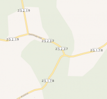
It looks particularly bad in Estonia, where most road numbers have five digits:

korvalteed.png (514×558 px, 26 KB)

https://github.com/gravitystorm/openstreetmap-carto/issues/4103 similar issues.

That one is about script/language differences. It seems unrelated.