Page MenuHomePhabricator

interactive map zooms to around 0N 0W
Closed, InvalidPublic

Description

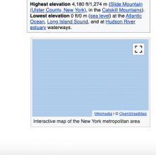
If I go to https://en.wikipedia.org/wiki/New_York_metropolitan_area and scroll a bit down, i see an interactive map. But it shows a map in the middle of the ocean, around where I expect 0N 0W.

Screen Shot 2020-04-23 at 2.48.56 PM.png (400×402 px, 35 KB)

This map is generated by

{{maplink|frame=yes|zoom=7|id=Q683705|type=shape|text=Interactive map of the New York metropolitan area}}

and uses https://www.wikidata.org/wiki/Q683705 . This has the correct coordinate location (40°48'31"N, 74°1'13"W ).
Event Timeline

TheDJ subscribed.

Kartographer doesn't care about what is in WikiData. It gets its shapes from Openstreetmap. So that means that likely someone broke the shape in OSM.

@TheDJ I'm a little confused.. it uses the Q-number as parameter, and I don't see any OSM linked from that item. Either way it seems undesirable that this then just shows 0,0. The fix may well be 'change the template' - but it looks to me that this is undesirable behavior right? Or am I overlooking something?

0,0 (aka null island) is just the default position of the map, and in this case basically means that the query to OSM for a map relations tagged with wikidata:Q683705 returned no results.

OSM stores Q numbers on shapes, Kartotherian queries a replication of the OSM database to retrieve the shape and Kartographer shows the results.
https://www.mediawiki.org/wiki/Help:Extension:Kartographer/OSM

The fix is

  1. remove the template or
  2. update OSM and tag the right shape with relation wikidata:Q683705

Kartographer doesn't care about coordinates and shapes as set on Wikidata, because those are just 1,5 years old, Kartographer and Kartotherian are 5 years old (3 of the last in maintenance only mode.)