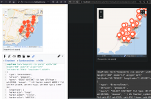
Steps to replicate the issue (include links if applicable):
- Create a map with both properties in the GeoJSON and a SPARQL query that gets properties from external. See example below.
- Preview or save the map.
What happens?:
Empty external data properties overwrite the default ones. In this example: Some pins do not have any markers (see left side of screenshot below).
What should have happened instead?:
Only properties with values should overwrite the default ones. In this example: All markers should have a default marker (circle), that gets overwritten with the specific ones (museum) if applicable (see right side of screenshot below).
Other information (browser name/version, screenshots, etc.):
Example that has default properties (GeoJSON) and properties via external data (SPARQL):
<mapframe text="Geopoints via sparql" width="300" height="300" zoom="13" align="left" latitude="43.735011" longitude="7.413197">
{
  "type": "ExternalData",
  "service": "geopoint",
  "query": "SELECT DISTINCT ?id ?geo (IF(?type = wd:Q33506, 'museum', '') AS ?marker_symbol) WHERE { ?id wdt:P17 wd:Q235; wdt:P31 ?type; wdt:P625 ?geo.} LIMIT 50",
  "properties": {
  "marker-size": "large",
  "marker-symbol": "circle",
  "marker-color": "#FF5733",
 }
}
</mapframe>