Page MenuHomePhabricator

Display more POIs in maps
Open, LowPublic

Description

Sometimes is very hard to find the correct place in map because there are only houses, ways, water and forests.
On high zoom there should be also displayed - hills, churches, chapels, wayside crosses and more.

This style is too much google-like.
I would like to see style more like mapy.cz-like

please, compare
https://mapy.cz/s/pezorafupo (mapy.cz)
https://www.openstreetmap.org/#map=15/48.8897/14.5050&layers=N (OSM)
https://www.google.com/maps/@48.8947741,14.4950549,15z (google)
https://maps.wikimedia.org/#15/48.8932/14.5001 (WMF)

on first two is easily identificable where is church - important landmark...
Event Timeline

Aklapper renamed this task from Display more POIs n maps to Display more POIs in maps.Apr 18 2021, 11:47 AM

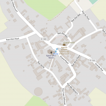
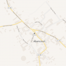
I support this request. Places of worship often serve as significant landmarks in the landscape. The tag "amenity=place_of_worship" should be displayed in a specific manner, as OSM does.

Capture d’écran 2023-11-23 à 11.16.32.png (1×1 px, 309 KB)
Wikimedia Maps (https://maps.wikimedia.org/#17/50.23493/3.21233)
Capture d’écran 2023-11-23 à 11.16.24.png (1×1 px, 637 KB)
OSM (https://www.openstreetmap.org/#map=17/50.23448/3.21223)

And why is the bus stop so visible in previous image? That doesn't make sense. The church with its bell tower is visible from hundreds of meters around. Not the bus stop.

TheDJ edited projects, added Maps (Map-Styles); removed Maps.