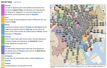
- Look for any use cases where the points are being used intentionally. For example, subway station markers are being styled.
- Should we think about a new feature exposing the nodes in a geoline? This is possible, for an example of styling these points see https://en.wikipedia.org/wiki/User:Adamw/sandbox/geoline_with_points . However, we would want to do some work to get meaningful labels for each node and so on. Added to the story time agenda for May 18.
- Review and merge the short-term fix to filter out nodes.
-
Create future task for filtering points out of the OSM import.The data might be useable, so instead I'm splitting out a future discussion about integrating under a new feature.
Since a few days, on Kartographer maps pushpin markers are shown in case of geoline objects. Pushpin markers should be shown only for single coordinates. The markers were placed by a Javascript script.
List of steps to reproduce (step by step, including full links if applicable):
- See map for instance at https://de.wikivoyage.org/wiki/Welterbe_in_%C3%84gypten
What happens?:
- There is a grey and unnumbered pushpin marker above the word "Ägypten" which belongs to the country's border line (a geoshape object). The is a similar behavior in case of geoline objects (for instance on public transport lines).
What should have happened instead?:
- No pushpin marker should be shown (the behavior as in the past five years).
Software version (if not a Wikimedia wiki), browser information, screenshots, other information, etc:
- Firefox 92.0.1


